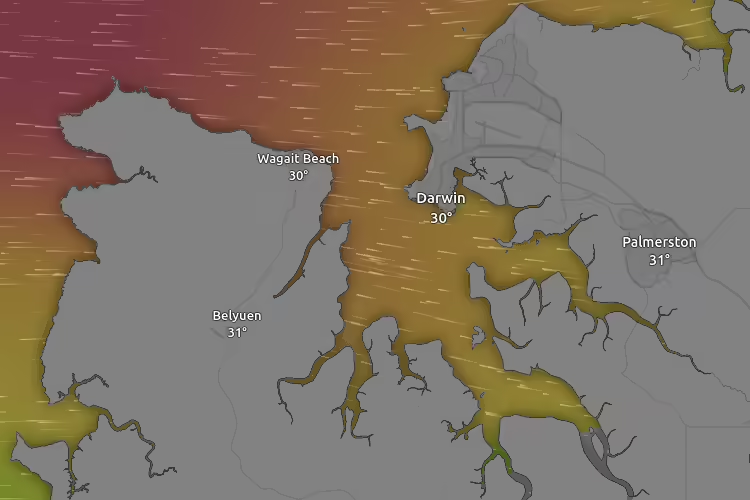
Interactive Live Maps of Darwin Tides, Currents, Wind, Weather & More . . .
Select a Live Interactive Map Below To View The Latest Real Time Weather, Wind, Tidal Currents & Visibility Data for The Northern Territory, Australia.


Harnessing Live Weather and Tide Information for Safer and More Enjoyable Sailing
Understanding the Importance of Live Interactive Map Data
For yacht owners and fishermen navigating the Northern Territory’s blue waters, access to real-time weather data is crucial. The darwintides.com website provides live interactive maps showing not just winds but also tides, currents, and visibility. This comprehensive insight aids in planning your sailing trips, helping to enhance overall safety and enjoyment.
Benefits of Live Interactive Maps in Fishing and Sailing
Live current maps available at darwintides.com significantly improve fishing opportunities. Fishermen can identify the best spots for catching various fish species, thanks to the accurate data on sea temperature and currents. For yacht owners, this information aids in ensuring a smooth sailing experience across the Timor and Arafura Seas.
Safety Considerations for Navigating Coastal Waters
While enjoying the Northern Territory‘s coastlines, safety should be your top concern. Keeping essential safety products handy, such as emergency beacons and flotation devices, is vital to ensuring a secure sailing experience. Additionally, having a man overboard rescue system on board can offer peace of mind to all crew members. Regular updates on tide and weather conditions from darwintides.com play a key role in keeping you informed and safe.
Latest Forecasts


Flying to Darwin?
Don’t Miss these Great Deals for Darwin Tides Readers from our eBay Partners
Limited Time Deals

View More in the Darwin Tides Shop